Today we'll build a simple tool to look up U.S. zip codes. Using only a zip code, we can learn the precise location of an address and calculate the distance from that location to any other place in the country.
Intro
This project is a clone of a Cocoa-based open source project. I thought the idea was fun and pretty useful, so I decided to convert it into a REALbasic project for ResExcellence readers. The zip code data that accompanies this project is a collection of numbered text files. These files comprise a complete (as of 1999) collection or "database" of all the zip codes in the United States. Accompanying each zip code is a city name, longitude, and latitude for location. In addition to these zip code data files, there are two files that contain the states and time zones of the various zip codes.
Our project will simply accept a zip code and attempt to find it in the zip code files. Once a match is found, the various information is pulled from the database. An enterprising REALbasic user might consider moving all of this data into a REAL Database for additional database manipulation abilities.
Build the Interface
The interface is the most time-consuming aspect of today's project. It's not really difficult to build, but its a bit tedious. If you'd prefer not to build the interface, you can download the finished project at the end of this tutorial.
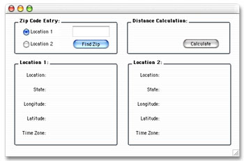
Begin by launching REALbasic and open Window1 by double-clicking it in the Project Window. To this window add the following controls:
| Control Type | Name | Other Info |
| EditField | ZipField | |
| RadioButton | RadioButton1 | Location1 |
| RadioButton | RadioButton2 | Location2 |
| PushButton | PushButton1 | Find Zip |
| PushButton | PushButton2 | Calculate |
| StaticText | loclabel | Index=0 |
| StaticText | loclabel | Index=1 |
| StaticText | statelabel | Index=0 |
| StaticText | statelabel | Index=1 |
| StaticText | longlabel | Index=0 |
| StaticText | longlabel | Index=1 |
| StaticText | latlabel | Index=0 |
| StaticText | latlabel | Index=1 |
| StaticText | zonelabel | Index=0 |
| StaticText | zonelabel | Index=1 |
| StaticText | distancelabel |
You can add labels and GroupBoxes to spruce things up as you see fit, but your completed interface might look like this:
Add the Code
The code segment of this tutorial is pretty easy to digest. You will need to place code in the Action events of PushButton1 and PushButton2. For starters, navigate to the Action event of PushButton1 and add this code:
dim s,temp,remainingzip as string
dim lasttemp as string
dim textin as textinputStream
dim f as folderItem
dim foundone as boolean
dim tempnum,group as integer
if radioButton1.value then
group = 0
else
group = 1
end if
if len(ZipField.text)<>5 then
msgBox "Zip code must be 5 digits long"
return
end if
// FIND :
// ZIP CODE LOCATION (CITY)
// LONGITUDE
// LATITUDE
s = left(ZipField.text,2)
remainingzip = right(ZipField.text,3)
foundone = FALSE
f = GetfolderItem("zipcodes").child(s+".txt")
if f<>nil and f.exists then
textin = f.openastextFile
while not(textin.eof)
temp = textin.readline
if left(temp,3)=remainingzip then
//we found a match !
longlabel(group).text = "-"+mid(temp,4,9)
latlabel(group).text = mid(temp,14,9)
loclabel(group).text = right(temp,len(temp)-22)
foundone = TRUE
end if
wend
textin.close
// FIND :
// ZIP CODE LOCATION (STATE)
if foundone then
f = GetfolderItem("zipcodes").child("states.txt")
if f<>nil and f.exists then
textin = f.openasTextFile
foundone=FALSE
while not(textin.eof) AND foundone=FALSE
temp = textin.readline
tempnum = val(left(temp,5))
if tempnum>val(zipField.text) then
//found the state!
foundone=TRUE
statelabel(group).text = right(lasttemp,2)
end if
lasttemp = temp
wend
textin.close
end if
//FIND :
// TIME ZONE
f = GetfolderItem("zipcodes").child("zones.txt")
if f<>nil and f.exists then
textin = f.openasTextFile
foundone=FALSE
while not(textin.eof) AND foundone=FALSE
temp = textin.readline
tempnum = val(left(temp,5))
if tempnum>val(zipField.text) then
//found the time zone!
foundone=TRUE
zonelabel(group).text = right(lasttemp,len(lasttemp)-5)
end if
lasttemp = temp
wend
textin.close
end if
else
MsgBox "Zip code not found."
end if
end if
Finally, navigate to the Action event of PushButton2 and enter this code:
dim distance,lat1,lat2,long1,long2 as double
dim x,y as double
lat1 = val(latlabel(0).text)
lat2 = val(latlabel(1).text)
long1 = val(longlabel(0).text)
long2 = val(longlabel(1).text)
x = 69.1 * (lat2 - lat1)
y = 53 * (long2 - long1)
//Approximate distance in miles
distance = sqrt(x * x + y * y)
distancelabel.text = format(distance,"########")+" miles"
These two pieces of code scan through the various text files to track down the city, latitude, longitude, and time zone of the desired zip code. From this information, we calculate a distance. Accompanying the original open source project as well as the download for this tutorial is a short document that lists additional distance calculations. We used the simplest (but most error-prone) calculation for the distance. You might try your hand at the others to see how they differ.
Conclusion
That's it for this week. You can download the completed project here. See you next week!